
Daniel Pereira dos Santos
Parceiro de vendas regional para a América Latina da OroraTech GmbH
OpCP70
Detecção e monitoramento de incêndios via satélites
Considerando a abordagem do manejo integrado do fogo, a detecção precoce de incêndios florestais é o segundo aspecto mais importante na busca pela redução dos danos relacionados a essas ocorrências, ficando em primeiro plano os esforços de prevenção a incêndios.
Para esse desafio, há relatos históricos de povos ancestrais que já se posicionavam em áreas mais elevadas, com o objetivo de detectar os incêndios ambientais. Com o tempo, começamos a construir torres de observação nesses pontos. E, bem mais recentemente, algumas dessas torres ganharam câmeras de vigilância.
Das câmeras de vigilância para sofisticados sistemas de detecção e monitoramento de incêndios florestais, a evolução foi natural. Hoje em dia, existem diversas dessas ferramentas com câmeras que conseguem detectar fumaça de incêndios florestais tão logo apareçam nos céus de nossas áreas rurais. Essas ferramentas, dependendo da condição de visibilidade do dia ou da noite, conseguem detectar fumaça em raios muitas vezes superiores a 20 km.
 Apesar das inúmeras vantagens dessas soluções ambas enfrentam seus desafios operacionais. Por exemplo, nas torres com profissionais, há dificuldades diversas no que tange às condições de saúde e segurança do profissional, como: dificuldade de deslocamento até a torre, inexistência de espaço adequado para alimentação e higiene pessoal, bem como exposição a intempéries climáticas, fazendo com que, em várias situações, o posto necessite ser abandonado para manutenção da sua segurança.
Já quanto aos sistemas com câmeras, os principais desafios são os ainda elevados investimentos necessários em equipamentos comparados à área de cobertura, sem falar nas situações climáticas adversas que podem reduzir muito a eficiência dos sistemas baseados em imagens captadas pelas câmeras, dentre outras situações. Dado que os incêndios florestais estão se tornando mundialmente uma ameaça cada vez mais presente, há várias iniciativas de detecção através de dispositivos instalados em satélites.
Em geral, esses sistemas usam dois tipos de equipamento: os satélites GEO (Geoestacionário) e os LEO (Low Earth Orbit). Os satélites GEO são equipamentos de alta órbita que viajam na mesma velocidade angular da Terra, permanecendo estacionários no mesmo ponto. Uma antena de satélite no solo pode, portanto, estar voltada para um ponto fixo no céu. Orbitam a uma distância de aproximadamente 36.000 km acima do equador; um satélite GEO pode fornecer informações de qualquer local da sua área de cobertura e pode detectar e monitorar incêndios que estejam produzindo uma relevante radiação, o poder radiativo do fogo, ou aproximadamente um incêndio com uma área de 30 x 30 metros.
Em geral, esses sistemas usam dois tipos de equipamento: os satélites GEO (Geoestacionário) e os LEO (Low Earth Orbit). Os satélites GEO são equipamentos de alta órbita que viajam na mesma velocidade angular da Terra, permanecendo estacionários no mesmo ponto. Uma antena de satélite no solo pode, portanto, estar voltada para um ponto fixo no céu. Orbitam a uma distância de aproximadamente 36.000 km acima do equador; um satélite GEO pode fornecer informações de qualquer local da sua área de cobertura e pode detectar e monitorar incêndios que estejam produzindo uma relevante radiação, o poder radiativo do fogo, ou aproximadamente um incêndio com uma área de 30 x 30 metros.
 Os satélites LEO operam mais perto da Terra (menos de 1.500m de altitude), portanto sua cobertura é muito menor (cerca de 2.000-3.000 km de diâmetro), e é por isso que as constelações LEO requerem um grande número de satélites para cobrir uma grande área. Os LEO atuais podem detectar áreas de incêndio menores, aproximadamente 10 x 10 metros.
Considerando a atual tecnologia de satélite, podemos resumir que o LEO pode detectar incêndios com muita precisão, e o GEO oferece monitoramento de incêndios quase em tempo real. Porém, as fontes de dados de satélite LEO existentes são apenas parcialmente suficientes para serem consideradas uma solução de detecção precoce, principalmente devido a lacunas de dados consideravelmente importantes no início da manhã, por exemplo, para Três Lagoas, no Mato Grosso do Sul, no Brasil, das 3h às 9h, e, principalmente, à tarde, onde muitos incêndios são iniciados, das 16h às 22h. Conforme a área de interesse no planeta Terra, verificaremos a mesma situação de duas grandes janelas, sem cobertura dos LEO a cada dia.
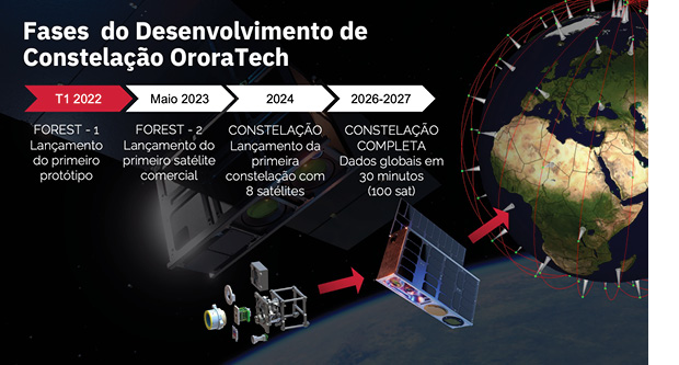
Por isso, há uma verdadeira corrida ao espaço por empresas como a OroraTech. A empresa possui um plano ambicioso de produzir sua própria constelação de nano satélites equipada com geradores de imagens multiespectrais na faixa de infravermelho térmico e visível. Combinando uma estrutura CubeSat, com patente pendente, com um sistema óptico personalizado e recursos de pré-processamento em órbita.
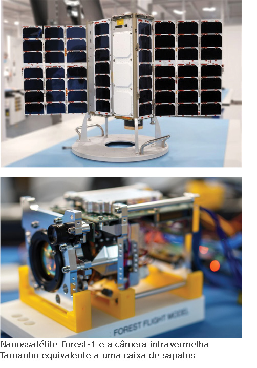
No início de 2022, a OroraTech lançou a primeira câmera infravermelha térmica não resfriada no espaço, chamada Forest-1. Essa conquista significativa foi um trampolim para a manutenção dos planos de constituição de uma constelação de satélites para uma revisita de 12 horas até 2024 e uma revisita de 30 minutos até 2026.
Com a constelação completa, a OroraTech, por exemplo, com processamento em órbita e melhor resolução de imagem, nos permitirá obter informações quase em tempo real para detecção e mapeamento de incêndios florestais, previsão de clima e muitas outras aplicações.
Como brevemente aqui demonstrado, essa corrida espacial encontra-se em curso, porém com muitas etapas ainda a serem alcançadas. Certamente, os próximos meses e anos serão altamente desafiadores para toda a indústria, mas estou confiante em que esse tipo de serviço ganhará uma relevância ainda mais significativa muito em breve.