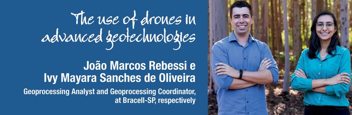
João Marcos Rebessi e Ivy Mayara Sanches de Oliveira
Analista de Geoprocessamento e Coordenadora de Geoprocessamento, da Bracell-SP, respectivamente
OpCP75
O uso de drones em geotecnologias avançadas
A jornada em busca de uma gestão sustentável dos ativos florestais, aliada ao aumento em eficiência operacional, contribuiu para que nas últimas décadas presenciássemos uma evolução tecnológica impressionante no setor florestal. A inovação, impulsionada pela necessidade de uma visão abrangente, capaz de englobar monitoramentos contínuos de florestas plantadas, ao mesmo tempo, em que proporciona detalhes específicos desses ativos biológicos para embasar um manejo florestal em dados concretos, tornou-se fundamental. E qual ferramenta poderia atender a essas necessidades aparentemente antagônicas?
Os drones, que emergiram como uma solução disruptiva e que conquistou seu espaço no setor florestal, capazes de fornecer perspectivas estratégicas e operacionais por meio de uma única plataforma. Nos últimos vinte anos, acompanhamos a revolução dos drones na gestão e manejo florestal. Para um diagnóstico mais profundo sobre o tema, é pertinente dividir essa evolução em três fases distintas.
A primeira foi basicamente um período de experimentação, no qual os drones foram utilizados para testes com câmeras simples, e pouca análise de dados atrelada a estes testes. A segunda fase marcou a integração dos drones com as geotecnologias, permitindo que as imagens capturadas fossem capazes de fornecer dados precisos para gerar análises localizadas e monitoramentos contínuos.
A aplicação de técnicas de Deep Learning contribuiu significativamente para a extração de informações objetivas e precisas, estimulando a atualização dos profissionais do setor em relação aos novos algoritmos e linguagens computacionais.
Este momento foi pautado por uma mudança de paradigmas, na qual o setor florestal, anteriormente limitado às amostragens, passou a compreender o comportamento total das áreas florestais em escalas centimétricas, e como qualquer ativo biológico percebeu-se que a variabilidade das florestas é um desafio que só pode ser superado por meio da silvicultura de precisão alinhada ao conceito Floresta 4.0. No âmbito operacional, o uso de GNSS (Global Navigation Satellite System), computadores embarcados e drones são a base para a implementação da Floresta 4.0. Consequentemente, houve uma tendência no escopo do planejamento florestal em direção ao uso de geotecnologias avançadas e na agilidade da obtenção de informações.
Atualmente entramos na terceira fase, justamente em um momento desafiador enfrentado pelo setor florestal no que diz respeito a mão de obra. A competição entre empresas do mercado intensifica a escassez de profissionais qualificados. Nesse cenário, a exploração de tecnologias como a Inteligência Artificial torna-se indispensável. A área de planejamento e controle florestal da Bracell se destaca por meio de uma Gerência de Geoprocessamento altamente qualificada e equipada com ferramentas de
última geração para garantir o equilíbrio entre qualidade, produtividade e custo.
O uso de drones modernos com sensores de imageamento e escaneamento atrelados a geotecnologias e inteligência artificial representa o ápice da modernização. Essa abordagem permite o planejamento, execução, monitoramento e colheita das florestas com base em informações precisas, além de proporcionar previsões assertivas para orientar decisões com projeção futura.
O investimento da empresa em drones de última geração é um diferencial. Equipamentos com alta capacidade operacional, sensores modernos para a coleta precisa de dados, computadores com alta capacidade de processamento, além de contar com uma equipe de profissionais qualificados em sensoriamento remoto, dedicados a análise de um grande contingente de dados, monitorando o desempenho das florestas e desenvolvendo novas metodologias para subsidiar as decisões da empresa em todas as esferas, desde estratégias macros até operações diárias.
Para tornar possível a implementação de soluções baseadas em sensoriamento remoto, é necessário reconhecer o valor da robustez das equipes primarizadas. Desde as equipes de drones até os profissionais responsáveis pela modelagem e análise de informações, visando garantir a constância na operacionalização dos produtos. Esta equipe especializada e focada exige alto nível de excelência no uso de geotecnologias avançadas.
A maturidade alcançada foi fundamental para a implementação de diversas soluções em sensoriamento remoto na Bracell nos últimos anos. Desde a prospecção de áreas, passando pelo planejamento operacional, monitoramento dos plantios até a chegada da madeira na fábrica, a tecnologia se faz presente em cada detalhe. Os ganhos em precisão, produtividade e redução de custos, alinhados à visão do cliente, solidificam a posição da Bracell como referência no setor.
Os drones e seus diversos sensores desempenham um papel crucial em iniciativas relacionadas ao ESG (Environmental, Social and Governance). Exemplos práticos incluem o uso do sensor LiDAR (Light Detection and Ranging) para planejar o aproveitamento do solo. Um sensor ativo que permite a construção de modelos tridimensionais do terreno. Este recurso viabiliza o planejamento preciso das atividades de topografia e alinhamento de plantio, alinhados as melhores práticas para conservação do solo.
Além disso, o mesmo sensor desempenha um papel crucial no monitoramento do perfil das florestas nativas. Mediante o reconhecimento de estrutura dessas florestas, é possível modelar e aperfeiçoar os cálculos dos estoques de carbono contribuindo para a elaboração de relatórios de sustentabilidade e embasando as estratégias de longo prazo da empresa, conforme o compromisso Bracell 2030, composto de metas ambiciosas da companhia alinhado com os Objetivos de Desenvolvimento Sustentável da ONU para 2030.
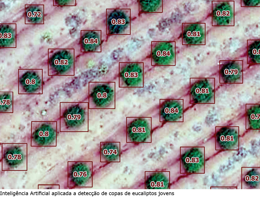
Outro exemplo é com a aplicação de IA (Inteligência Artificial) nas imagens capturadas pelos drones possibilitando a contagem de mudas em área total dos talhões, eliminando a necessidade de alguns tipos de amostragem. Também permite uma auditoria nos processos de silvicultura para garantir a qualidade das operações emitindo alertas automatizados e georreferenciados para áreas com incidência de falhas, baixo crescimento e mato competição, otimizando o tempo, o melhor dimensionamento de equipes e proporcionando tratativas localizadas.
É importante ressaltar que as soluções mencionadas acima são o estado da arte da aplicação da tecnologia em sinergia entre as áreas de Sensoriamento Remoto, Qualidade Florestal e Silvicultura, demonstrando um compromisso na busca pela melhoria contínua.
Embora entusiastas da tecnologia, é crucial reconhecer os desafios associados à inovação acelerada. É preciso lembrar que as imagens de drones, satélites, LiDAR, radares e outras tecnologias têm gerado uma quantidade imensa e complexa de dados com um grande poder de agregar valor aos processos, chamado de Big Data.
Estariam as empresas e as pessoas preparadas para a mudança? Mudar padrões, processos e pessoas é desafiador, mas deve ser enfrentado. Para prosperar na era da inovação, promover uma cultura de aprendizado contínuo é fundamental. Apenas dessa forma poderemos garantir o sucesso do setor e o desenvolvimento dos profissionais.