
Daniel Henrique Breda Binoti
Coordenador de Mensuração Florestal da Eldorado
OpCP71
Tecnologia de mapeamento de matocompetição
Coautores: Jonas Luís Ortiz e Adalto Moreira Braz, Especialistas em Geoprocessamento da Eldorado
O manejo eficaz de plantios florestais envolve vários fatores. Alguns são técnicos, como a melhor época para aplicar tratamentos silviculturais; biológicos, como o potencial produtivo de uma determinada espécie ou clone em um determinado solo ou tipo de terreno; outros são econômicos, como preços de madeira ou custos de produção; e outros ainda são sociais, como leis e tributos que afetam a comercialização e o trabalho empregado em várias etapas do processo de produção.
O manejo eficaz de plantios florestais envolve vários fatores. Alguns são técnicos, como a melhor época para aplicar tratamentos silviculturais; biológicos, como o potencial produtivo de uma determinada espécie ou clone em um determinado solo ou tipo de terreno; outros são econômicos, como preços de madeira ou custos de produção; e outros ainda são sociais, como leis e tributos que afetam a comercialização e o trabalho empregado em várias etapas do processo de produção.
Além da complexidade do processo de manejo dos plantios florestais, os gestores estão expostos a uma acirrada competição entre as empresas do setor, o que exige uma rápida e assertiva tomada de decisão na escolha de prescrições e tratos silviculturais. Nesse cenário, o sensoriamento remoto tem ganhado um expressivo avanço em função do baixo custo e da crescente disponibilidade de novas tecnologias de imageamento.
O sensoriamento remoto consta num conjunto de técnicas voltadas à obtenção de informações sobre objetos, por meio da captação da radiação eletromagnética, de maneira que não haja contato entre sensor e alvo. Desde seu surgimento, essa geotecnologia tem se difundido em inúmeras atividades, dado seu poder de captura de imagens, desde pequenas áreas até dimensões continentais, em múltiplas escalas e diferentes níveis de detalhe.
Atualmente, os gestores florestais contam com diferentes plataformas de aquisição de imagens de fontes nacionais e internacionais, gratuitas e comerciais, que são complementares em termos de aplicações. A ampla disponibilidade de imagens favorece a cobertura completa da área de atuação, em qualquer época do ano, o que tem intensificado o monitoramento detalhado dos fenômenos recorrentes sobre florestas, num contexto histórico e até mesmo diário.
O desenvolvimento de alternativas para o monitoramento dos plantios jovens de eucalipto a partir de produtos de sensoriamento remoto e sistemas de informações geográficas se torna viável quando automatizado por linguagens de programação, e seu gerenciamento, feito por bancos de dados estruturados.
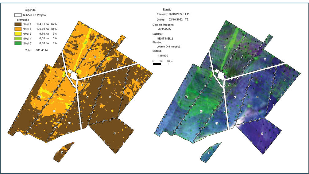
O monitoramento das florestas jovens de eucalipto pode ser feito com diversas técnicas, contudo a principal delas é resultado do mapeamento da estimativa do nível de biomassa foliar nas áreas de interesse. Essa estimativa é identificada a partir do índice espectral de vegetação NDVI (Normalized Difference Vegetation Index).
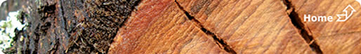
O cálculo do NDVI é realizado por meio da razão entre bandas espectrais que consideram o espectro do infravermelho próximo (NIR) e o vermelho visível (RED). De um modo geral, quanto maior o valor do NDVI, maior a área ocupada por vegetação fotossinteticamente ativa em determinado local. E, quanto menor o valor do NDVI, maior a área ocupada por solo exposto no talhão. Após o processamento das imagens de satélite, as informações são gravadas, em bancos de dados, gerando o quantitativo de área absoluta (hectare) e relativa (porcentagem) de cada classe do nível de biomassa encontrado em cada talhão e projeto da área de interesse. Juntamente com o mapa do nível de biomassa, deve-se analisar o mapa-imagem em composição colorida falsa cor, resultante de um mosaico composto por três bandas espectrais, que contrasta e realça tonalidades de cores associadas, na maior parte dos casos, a padrões de cobertura do solo presentes em cada classe do nível de biomassa.
Via de regra, áreas representadas por tons de verde fluorescente estão relacionadas a ocorrência de infestações de alta severidade por ervas daninhas e rebrota na entrelinha em reforma; e tons mais próximos de rosa/roxo, a solo exposto. Posteriormente, todos esses produtos são analisados pelas equipes operacionais, de apoio e de tomada de decisão, sendo necessária a validação em campo das estimativas geradas.
Os produtos podem ser analisados de duas maneiras: para alterações, que são comparativos entre diferentes datas de imagens, e para diferenças, em que é detectada a variabilidade do nível de biomassa em uma única data. As variações de biomassa evidenciadas nos talhões podem ser devido à presença de mato (implantação/rebrota/reforma) e/ou rebrota na entrelinha em reforma, diferenças no crescimento/desenvolvimento do eucalipto, doença, praga; sinistro; e tudo isso é indicativo para intervenção na floresta, auxiliando a gestão e a tomada de decisão.
Os produtos implementados orientam/subsidiam, de forma sistemática, as áreas de silvicultura, de qualidade e tecnologia florestal, no campo, além de gerar evidências para os relatórios gerenciais. Somente em campo, o silvicultor conseguirá identificar o porquê dessas alterações, diferenças e variações; e se mato e/ou rebrota, se essa presença está realmente competindo com o plantio e a necessidade de intervenção com operação de capina/roçada e/ou aplicação de pós-emergente.
Como desenvolvimento, os estudos para a modelagem da estimativa do nível de biomassa foliar, considerando pesos a fatores que interferem no valor do NDVI, como a época do ano em que o talhão foi plantado, a época do ano da data de aquisição da imagem, as idades do plantio e o regime de manejo aliados a algoritmos de inteligência artificial, podem melhorar ainda mais esses produtos.
Além disso, o crescente mercado de sensoriamento remoto permite “vislumbrar” a integração de outros sensores para esse tipo de monitoramento, como o de sensores passivos (ópticos) e ativos (radar). Radares imageadores possibilitam uma maior resolução temporal, já que, diferente dos sensores óticos, permitem que os dados sejam obtidos independentemente das condições climáticas, como presença de chuva, fumaça, nuvem, sombra etc. e têm a capacidade de obter dados independentemente da energia solar, ou seja, a obtenção de dados é possível tanto durante o dia, quanto à noite.
Consideramos que o principal desafio seja acompanhar o rápido desenvolvimento de tecnologias de armazenamento, comunicação, informação e processamento, aliado à operacionalização das soluções em sensoriamento remoto, com a integração e disponibilização dos resultados através de produtos cartográficos, relatórios, serviços de consumo em plataformas de WebGIS (local ou mobile).